Gas Monitoring for Earthquake Precursors
Long before an earthquake reaches the surface, the rocks beneath our feet are already reacting. Stress builds along fault systems, micro-fractures open new pathways, and gases trapped deep underground — carbon dioxide (CO2) above all — find their way up.
For decades, geoscientists have asked the same question: can these subtle geochemical signals be measured and tracked closely enough to serve as early-warning indicators before an earthquake happens?
This is the world of soil-gas and subsurface gas geochemistry, where geology, geophysics, and environmental monitoring meet, a field that also overlaps, in its methods and instrumentation, with the monitoring of Carbon Capture and Storage (CCS) systems, where the focus shifts from natural gas emissions to tracking CO2 that has been deliberately captured and stored underground.
Our automated gas analysis system sits at the crossroads of these fields. Through a collaboration with HUN-REN (the Hungarian Research Network) and its Pannon LitH2Oscope research group, we take part of an international research network by providing our technology to two on-site laboratories in Central and Eastern Europe: Covasna (Romania) and Badacsonytördemic (Hungary).

Gases Are a Window Into the Underground
CO2 is far from being just a greenhouse gas problem for the atmosphere. It is also one of the most sensitive tracers geologists have to understand what is happening kilometers below the surface. In seismically active regions, CO2 along with Radon and other trace gases, migrates upward from deep sources through fault systems and fractured rock, eventually reaching the soil or the atmosphere.
Because this migration is controlled by the same structures that accumulate and release tectonic stress, researchers have long hypothesized that changes in gas flux or concentration, sudden spikes, anomalous patterns, deviations from a seasonal baseline, could act as precursory signals, appearing hours, days, or even weeks before a seismic event. Reviews on the subject describe how both direct and indirect sampling methods are used to measure CO2 and Radon in seismically active areas, with Radon in particular considered a possible short-term precursor of fault reactivation [Néda, T. et al., 2008].


Gases from Deep Within: Hungarian Study Offers New Perspective on Climate and Earthquake Research
This is not a new idea: pioneering work on gas emission monitoring in Romania dates back to the 1970s, when Airinei and Pricăjan first documented complex, non-random rhythms in the CO2 output of natural gas vents in the Călimani–Gurghiu–Harghita volcanic range, occurring on timescales ranging from a few days to several years [Airinei & Pricăjan, cited in Gergely et al., 2025].
Why Romania and Hungary?
Covasna and Badacsonytördemic sit roughly 700 km apart, but they belong to the same geodynamic story. The opening of the Pannonian Basin, where Hungary largely sits, is directly linked to what has been happening deeper down at the bend of the Carpathians. Badacsonytördemic itself sits on the slopes of an extinct volcano tied to that same history of crustal stretching.
Near Covasna, that story becomes most dramatic: the Vrancea zone hosts one of the most active intermediate-depth seismic areas in Europe, with earthquakes occurring 60 to 180 km deep in an unusually small, confined volume of the mantle. Decades of research still haven't settled why, some see it as the last remnant of a sinking oceanic slab, others as a delamination of continental lithosphere. What's clear is that Vrancea doesn't behave like a typical subduction zone, which is exactly why it's so closely watched.
Running parallel stations in both countries lets researchers follow the same regional system from two complementary vantage points: one close to where the deep seismicity concentrates, the other further out on the stretched, volcanically active edge of the same basin.
Other Natural Laboratories Across Europe
Europe hosts several places where deep-origin CO2 reaches the surface naturally, remnants of past volcanic activity, deep crustal fractures, or geothermal systems. These sites, often called mofettes or CO2-rich gas vents, have become valuable open-air laboratories for geoscientists.
In Italy, the Latera caldera north of Rome is one of the most studied CO2 degassing sites in Europe, where deep gas migrates to the surface along buried and exposed faults (Annunziatellis et al., 2008). Off Panarea, in the Aeolian Islands, submarine CO2 seeps have been used to test acoustic and diving-based monitoring techniques (Caramanna et al., 2011). In the Cheb Basin, Czech Republic, a multidisciplinary approach combining infrared spectroscopy, soil-gas surveys, and geoelectrical methods has been developed and validated on a naturally degassing area (Schütze et al., 2012).
What these sites share is a simple idea: you can't fully validate a gas-monitoring technology in the lab. You need a place where real geological processes are already producing the signal you're trying to detect, over months or years, under real conditions. Covasna and Badacsonytördemic belong to this same family of natural laboratories, with the added dimension that here, the question is not only about carbon storage, but about earthquake prediction.
Two Stations, One Research Network
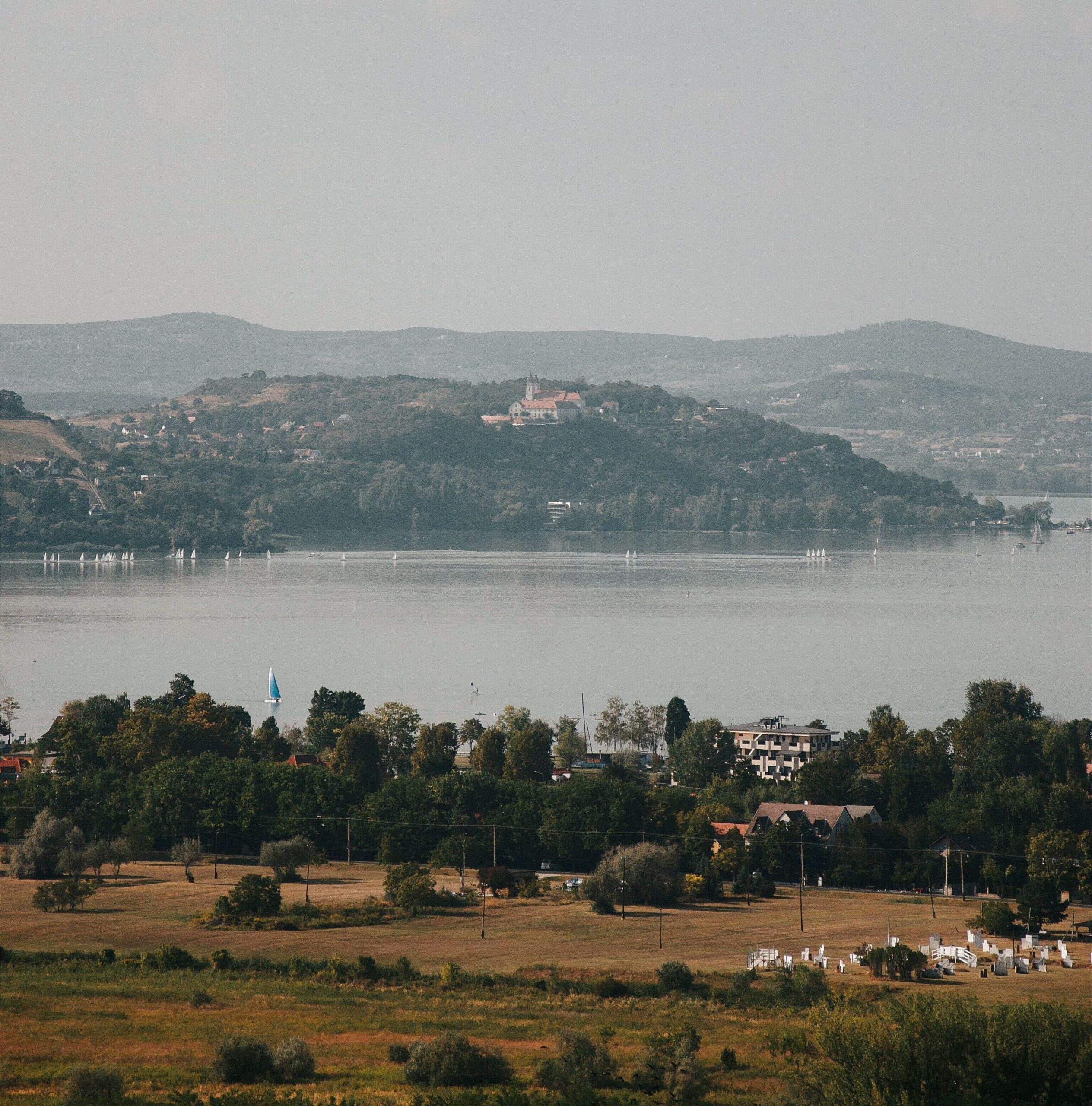
We installed a parallel station later in Hungary together with other instruments, at Badacsonytördemic, on the slopes of the extinct Badacsony volcano overlooking Lake Balaton.Inaugurated in 2021, it was described by its research team as the first station of its kind in Hungary and Eastern Europe, simultaneously tracking seismic activity, the flux of gases from the Earth's interior, meteorological parameters, and the electromagnetic properties of the subsurface, with a twofold goal: identifying geological processes that precede earthquakes, and better understanding the global carbon cycle (Kovács et al., 2023). Around the station, researchers have identified degassing sites along fault lines where rock layers have fractured or shifted slightly — visible evidence of the same deep gas migration the station is designed to track (HUN-REN, 2025).
It is here, in Covasna, that an Integrated Geodynamic Station was installed as part of the Topo-Transylvania project, a long-running Dutch-Hungarian-Romanian research collaboration studying the geological evolution of the Carpathian bend (HUN-REN, 2021). The station provides a continuous stream of data on diffusely emanating CO2 in soil gas and the atmosphere, alongside a dedicated monitoring point at one of the local mofettes (HUN-REN, 2021; Szakács, 2021), and it is also where our own gas analysis system has been installed and operating, as part of the station's instrumentation (more on this below).

REDshift CCS System: Automated FTIR-Based Gas Analysis
For both stations we provided a fully automated gas sampling and analysis equipment built around Fourier-Transform Infrared (FTIR) spectroscopy, designed for unattended operation 24/7, year-round.
An instrumented workbench, housed in a climate-controlled cabinet, with FT-IR and long path cells included in a Nitrogen-purged closed box.
The system compares continuously the CO2 emitted from underground (via a dedicated borehole) with ambient atmospheric CO2, without disturbing the source — a challenge shared by other continuous gas-monitoring efforts in the area (Gergely et al., 2025).
Key design features include:
- An FTIR analyzer covering 4000–600 cm⁻¹, with the main CO2 absorption band around 2250–2400 cm⁻¹. (PerkinElmer FT-IR provided by Per-Form).
- Two heated infrared gas cells: a short-path cell (0.8 m) and an adjustable long-path cell (0.8–8 m), allowing the system to resolve lower concentrations or different target gases as needed.
- Both cells sit inside a Nitrogen-purged, sealed cabinet, isolating measurements from ambient humidity and background CO2.
- Heated transfer lines and cells prevent moisture condensation, a real risk running unattended outdoors for months at a time.
- The system automatically alternates sampling between the two cells, flushing the idle line with Nitrogen to avoid delay or memory effects.
- An onboard compressor and Nitrogen generator (99.95–99.98% purity) make the system self-sufficient, with no external gas bottles to replace.
- The acquisition software manages the full scanning cycle and exports data into a simple, Excel-readable table.
- The entire station can be monitored and controlled remotely over a standard internet connection.

Where the university's own sensor arrays capture fast, high-resolution local dynamics inside a single mofette pool, our system runs a long-term, laboratory-grade comparison between deep-source gas and the surrounding atmosphere — one of the "eyes" of both geodynamic stations, in Covasna and in Badacsonytördemic.
From Earthquake Precursors to Carbon Storage: A Shared Monitoring Challenge
Both stations were designed with more than one purpose in mind: earthquake precursor research, environmental monitoring of subsurface gas emissions, and a better understanding of the global carbon cycle. It is the reason this same kind of continuous underground gas monitoring extends naturally beyond seismology, into environmental surveillance, and into a very fast-growing field: Carbon Capture and Storage (CCS).
In CCS, CO2 captured from industrial emissions is injected deep underground for permanent storage. One of the central challenges of the technology is verifying that the stored CO2 doesn't migrate back toward the surface over time (known also as leakage, or seepage). Monitoring, Reporting and Verification (MRV) programs around CCS sites rely on exactly the kind of soil-gas and atmospheric CO2 measurements described here, to detect any sign of leakage long before it could become significant (IPCC, 2005).
To develop and validate these leak-detection methods, researchers rely on so-called natural analogue sites, places where geogenic CO2 already rises naturally to the surface from deep sources, offering real-world conditions to study how gas actually behaves on its way through the subsurface, and to calibrate field instruments accordingly. Naturally CO2-emitting sites like Latera, in Italy, have been used for years exactly for this purpose (Annunziatellis et al., 2008; Beaubien et al., 2008). Covasna and Badacsonytördemic sit in that same lineage — even though their primary research question here is seismic, not storage-related.
We would like to explore that connection in more depth in a follow-up article related to CCS, including what naturally CO2-emitting sites around the world can teach engineered CO2 storage projects. For now, what's worth taking away is this: two research stations in the Carpathians and on the shores of Lake Balaton are quietly generating continuous, high-resolution data on how gas moves through the Earth's crust, in the hope that, one day, the ground might tell us it's about to move before it actually does.
Papers & Scientific Sources
- Gergely, A., Szakács, A., Gál, Á., Néda, Z. (2025). CO2 Dynamics in a Mofette: Measurement and Modeling. Geosciences, 15(9), 368. https://doi.org/10.3390/geosciences15090368
- Kovács, I., Szakács, A., Szabó, Cs., Novák, A. et al. (2023). Integrated Geodynamic Stations in Central Europe. Conference paper. https://www.researchgate.net/publication/376432678
- Annunziatellis, A., Beaubien, S.E., Bigi, S., Ciotoli, G., Coltella, M., Lombardi, S. (2008). Gas migration along fault systems and through the vadose zone in the Latera caldera (central Italy): implications for CO2 geological storage. International Journal of Greenhouse Gas Control, 2, 353–372. DOI: https://doi.org/10.1016/j.ijggc.2008.02.003
- Beaubien, S.E. et al. (2008). The impact of a naturally occurring CO2 gas vent on the shallow ecosystem and soil chemistry of a Mediterranean pasture (Latera, Italy). International Journal of Greenhouse Gas Control, 2(3), pages 373-387 (verificare — diverso dal paper sopra). DOI: https://doi.org/10.1016/j.ijggc.2008.03.005
- Caramanna, G. et al. (2011). Laboratory experiments and field study for the detection and monitoring of potential seepage from CO2 storage sites. Applied Geochemistry. DOI: https://doi.org/10.1016/j.apgeochem.2012.09.009
- Schütze, C. et al. (2012). Natural analogues: a potential approach for developing reliable monitoring methods to understand subsurface CO2 migration processes. Environmental Earth Sciences. DOI: https://doi.org/10.1007/s12665-012-1701-4
- Szakács, A. (2021). Precursor-Based Earthquake Prediction Research: Proposal for a Paradigm-Shifting Strategy. DOI: https://doi.org/10.59277/RRG-RJG.2023.01
- Cseresznyés, D. et al. (2023). Surface occurrence of dawsonite and natural CO2 emanation in Covasna, in the Eastern Carpathians: A stable isotope study. Chemical Geology. DOI: https://doi.org/10.1016/j.chemgeo.2023.121883
- Néda, T., Szakács, A., Cosma, C., Mócsy, I. (2008). Radon concentration measurements in mofettes from Harghita and Covasna Counties, Romania. Journal of Environmental Radioactivity, 99, 1819–1824. Link: https://www.sciencedirect.com/science/article/abs/pii/S0265931X08001239?via%3Dihub
- A geochemical traverse across the Eastern Carpathians (Romania): Constraints on the origin and evolution of the mineral water and gas discharges. DOI: https://doi.org/10.1016/j.earscirev.2026.105528
- IPCC (2005). IPCC Special Report on Carbon Dioxide Capture and Storage. Cambridge University Press. https://www.researchgate.net/publication/239877190_IPCC_Special_Report_on_Carbon_dioxide_Capture_and_Storage
Additional Sources & Links
- HUN-RÉN Institute of Earth Physics and Space Science — press release, "A Topo-Transylvania csapat újra Kovásznán" (2021). https://epss.hun-ren.hu/en/a-topo-transylvania-csapat-ujra-kovasznan/
- HUN-RÉN — "Gases from deep within: Hungarian study offers new perspective on climate and earthquake research" (2021). https://hun-ren.hu/research_news/gases-from-deep-within-hungarian-study-offers-new-perspective-on-climate-and-earthquake-research-108618
- Pannon LitH2Oscope research group (Lendület). http://lendulet.ggki.hu/
- Interview — Dr. István Kovács on the Integrated Geodynamic Station in Covasna. https://www.instagram.com/reels/DOk7992jZeA/